A71/028
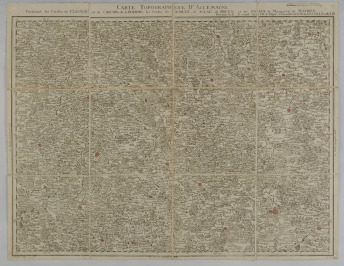
TOPOGRAPHIC MAP CARTE TOPOGRAPHIQUE D´ALLEMAGNE FEUILLE LIII
1787(9) Frankfurt am Mein
Carte Topographique d`Allemagne. fait par I & K se vend chez I. W. A. Iaeger s Francfort sur le Mein A. P. d. S. M. I. ; H. Cöntgen sc. Mog. Feuille LIII, Contenant les Cercles Czasslau, et de Chrudin, de la Boheme, les Cerdes de Olmütz, de Iglau, de Brunn et de Znaim du Margraviat de Maehren
Engraved by: Coentgen, Heinrich Hugo, 1727-1792.
Maps mounted on canvas, red-coloured bigger towns with fortification.
66x51 cm
Sheet LIII of the first systematically constructed map of the entire German region for the first time in an almost uniform scale of 1:210,000 to 1:225,000. (Lex. Cartography I, 353). The detailed map shows the area between Litomyšl, Zábřeh and Olomouc in the north and also Budějovice, Krumlov and Brno in the south.


 Czech
Czech English
 German

 Loading higher resolution